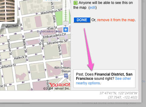
Or something like that anyway. Over on the artsy Flickr Blog we Introduce a new way to geotag, which has a nice pop-up map, which you can drag around, or just enter in the latitude/longitude by hand, something amazingly you couldn’t just do before.
However, ‘ere on the Dev blog there’s something else that interests us about this. A thing we call “Corrections” and it’s tucked down at the bottom when you go edit a photo’s location …

So what’s it all about?
Well something we’ve been fighting, tweaking, exploring for the last forever is getting the Reverse Geocoding working in a way that makes everyone happy.
In a nutshell Reverse Geocoding is when you take a Latitude and Longitude and then say where that point is. Ideally in a way that’s sensible to humans. In the above image you ask, “Where’s 37.7947N 122.402W?” and we used to say “San Francisco”.
We used to stay at the general city level because it turns out that people get more upset at being told they live/work/take photos in the wrong neighborhood than having no neighborhood at all.
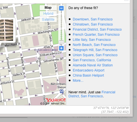
Turns out the solution we’ve gone with it just simply to ask, at least in the first instance …

Due to wonderful design we hopefully make this all look very easy, but let me tell you, it’s not, it’s all terribly, terribly hard. But more on that in a second.
So now on photos we’re saying which Neighborhood we think the photo (or video) is taken in, and let you tell us otherwise.
The grand idea is that if enough people start to ‘correct’ a neighborhood then we can feed that knowledge back into the system and slowly over time get our database to match what our actual users say.
The problem has moved slightly from “Why does it say my photo was taken in xxxx” to “Why doesn’t it list alternative place xxx”, but that’s a slightly better problem … anyway …
I’ll cover how people can start to get this back out again, so we can all share the love in another post soon.
On a slightly more philosophical level, it’s a never ending process. We’ll never reach a point where we can say “Right that’s in, all borders between places have been decided”. But what we should end up with are boundaries as defined by Flickr users.
As an example a lot of our UK neighborhood data comes from government and local council records (probably). And while that data is very good for the purpose it was originally gathered for, it turns out people can be very specific and touchy about someone telling them they live in Upper Tinshire or Lower Tinshire, when clearly they live in the other one, because obviously this side of the street all the way up to the Post Office is Upper Tinshire and the Fox and Hound Inn Round-a-bout represents the border, of course, Duh!
And this goes on around the world all the time.
For us, it’s a first small step into an experiment, and actually a pretty big experiment as we’re potentially accepting “corrections” from our millions and millions of users. We’re not quite sure how it’ll all turn out, but we’re armed with Maths, Algorithms and kitten photos.
Rock on!
Related: A while ago the lovely people at O’Reilly asked us if we’d like to talk about something at Where 2.0. Which was nice, and as we didn’t have anything to particularly promote or sell it left us free to talk about what was interesting to us, which turned out to be this very thing.
So if you want to see two people say “Errrrr” and “Ummmmm” a lot (according to Aaron, I haven’t seen it myself as I can’t stand watching myself talk) for 15mins saying pretty much what I typed up there, but with a cool bit by Aaron where he talks about how hard Reverse Geocoding is, then here’s a video …
The Video
And here are the slides…

