New SSL Endpoints for the Flickr API

Sometime in the last few months, we went and updated our API SSL endpoints. Shame on us for not making a bigger deal about it!

In the past, to access the Flickr API via SSL you needed to use the “secure.flickr.com” subdomain… Not anymore!

Now calling the API via SSL is as easy as updating your code to call:

https://api.flickr.com/

In fact, it’s so easy that we want everyone to use it.

You’ll notice in the API documentation that all of the endpoints have been updated to https. While OAuth adds security by removing the need to authenticate by username and password, sending all traffic over SSL will further protect our users’ data while in transit.

The SSL endpoints for the Flickr API are:

https://api.flickr.com/services/rest/
https://api.flickr.com/services/soap/
https://api.flickr.com/services/xmlrpc/

And for uploads:

https://up.flickr.com/services/upload/
https://up.flickr.com/services/replace/

Later this year we will be migrating the Flickr API to SSL access only. We’ll let you know the exact date in advance, and will run a blackout test before the big day. For applications that use well established HTTP client libraries, this should only require updating the protocol and (maybe) some updated configuration. We’ll also be working with API kit developers, so updating many apps will be a git pull away.

Of course we realize that this change might be more difficult for some. We’ll be following the Developer Support Group closely, so please let us hear your questions, comments, and concerns.

This is the first step of many improvements that we’ll be making to the API and our developer tools this year, and we’ll post additional details and timelines as we go. Want to help? We’re hiring!

[changelog] “Find my location” button

I just added a button to the Explore Map and the pop-up map you see when geotagging your own photos from the photo page (organizer support v.soon).

Using my l33t Skitch skills I’ll attempt to highlight it …

Getting ready for a code blog post

… but WAIT! You may not see it! It’s one of those “Power-User” type things…

To get the button to show up you’ll need some form of geo-locating built-in/plug-in type thing, or maybe you’re all smarty-pants and running a cutting edge beta version of a browser with location finding built in already. Perhaps you’ve already installed Google Gears, in which case we’ll use that.

Probably the easiest way of getting the button to appear is to pop over to the Loki site and click the “Try it Now” button, install the plug-in, then pop back to Flickr. Loki is from the SKYHOOK Wireless peeps, who all the cool kids seem to be using.

You can also click over to the Mozilla Labs and read more about their Geode project, about how location stuff will soon be built into browsers and everything and install their geode plug-in from there.

Either way, it’ll check all three “things” and show the button if it finds one, as more options come along I’ll add those too.

As an aside …

This is why you shouldn’t do graphical buttons and multi-language support at the same time.

This is why you shouldn't do graphical buttons and multi-language support at the same time.

… nightmare!

[changelog] Revision of the Places page, also Neighborhoods

A slightly overdue (and longer than it was supposed to be) post, considering this happened a while ago, but I thought I’d mention a few subtle updates to the Places page.

Even before that though we’ve added neighborhood links to the Photo pages, before we just listed the neighborhood …

Neighborhood Link

… now its a link through to the Places page itself, which look rather like this …

Neighborhoods (South Bank)

Meaning that from a photo that’s been geotagged you’ll be able to get more of a feel for the local area. Obviously this work better in large Cities where the neighborhoods themselves can be as big as towns, while in the towns you’re more likely to find the one or two photographers who count each neighborhood as their stomping ground.

I guess that’s the big addition, but we also tweaked a few other things at the same time, here’s a before and after shot, you’ll probably need to click through to the larger size if you want to see the details.

Old and Updated Places Pages

On the left side of each Places page we’ve moved different elements around, pushing the search further up, the date/time down and scrapping the weather altogether now that we’ve established that it rains in London.

The functional changes over on the right involved moving the title, attribution, Next & Previous buttons off the photo. When we launched Places we didn’t have Videos, and now we do and the old position clashed with the video controls.

The other benefit of the Next/Prev moving to above the photo is that they dont jump around as the photos resized. We also added key controls, now you can just press the forward and back cursor buttons on the keyboard to keep going through photos, power user tip!

The “paging” buttons no longer hover over the top of the thumbnails, as they were …

  1. Annoying.
  2. Not always obvious.


On a more technical level, now only geotagged photos appear on the Places page, and where possible the location shown on the map (sometimes with Neighborhoods, due to the nature of the beast, they can be just off the edge of the map).

Big obvious arrow demonstrating the feature :) …

Geotagged

When we first launched the Places page we wanted to make sure that each location had plenty of photos, so we used a combination of geotagging and tags/description to automate the selection of them. Which lead to interesting results such as the city of Reading in England featuring a lot of photos about books (tagged reading, natch). Now that we have over 100 Million geotagged photos we’ve switched to “just” them.

We also factor in the Season a photo was taken in to select the interesting ones, to give us a bit more change in the first photos you see and too keep them relatively, well, seasonal. We’ll probably tweak this again soon to get them to rotate even more often, but still working through that one.

City Colours and Endless Photos

As mentioned above we moved the time down and, partly for whimsy, partly because they’re really useful, used the Dopplr colour to display it and link their pages. Here’s our Los Angeles page and Dopplr’s Los Angeles page, Dopplr decided to use Flickr to select photos for each City they know about, so we thought we borrow their colour in return :)

You can read more about how Dopplr (and therefor us) calculate the colour for a place over on their blog: In rainbows and Darker city colours.

Dopplr And Single Row

Finally, because I’ve gone on enough already, the old design used to have two rows of thumbnails under the main photo and a total of 72 photos, meaning there were 6 “pages” of thumbnails. When you got to the last page, that was kinda it, you couldn’t go any further.

Instead there’s now just one row, but I bolted on the API, so it keeps trying to load more and more photos as you get close to the end of the current lot. Instead of just 72 photos for Los Angeles there’s now the full (currently) nearly half million 444,594 photos.

Which reminds me, we should probably add a Slideshow that that page :)

And that’s the revised Places page.

[Edit: Oh and I know we’ve just launched Stats (again), but it’s nice to give the dev a couple of days to recover before forcing them to write a changelog about it ;) ]

[changelog] Delete Tag Cross Things inspired by Delete Tag Cross Things

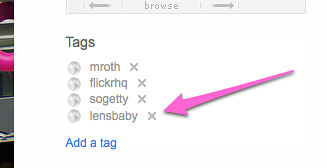
Proving that no change is too small for [changelog] (and that I need to keep on top of them a little more) as spotted over in the Help Forum: “tags look different” thread, a change in the deleting “x” on Tags.

Dunstan and Ross snuck^H^H^H^H^H rolled out the change out on Friday and it looks something like this …

delete tag

Worth noting that Dunstan goes on to sayThey all might end up a bit smaller, and a bit lighter. We’ll just live with them for a little bit and see how they go.” … at which point I’ll post another changelog or not, depending on what happens :)

As no change is without a protest group feel free to register your outrage over in the Flickreenos Against **New Xs** Group. Or at least until the next change comes out, at which point the protest group will move onto that.

[changelog] Yahoo! updated map tiles and some OSM ones.

Recently Yahoo!! released new map tiles … ah heck, actually it was a couple of months ago, I just suck at writing blog posts … anyway, here’s their post from last December: Yahoo! Maps – New International Coverage which goes on to say …

“We’ve added detailed coverage to 45 new countries, with new data in a further 30 countries, to make it easier for you to navigate to exotic locales as you plan for your winter travel.”

I’m as keen as the next person to have 45 new countries, so I bumped our version of the maps API used over here at Flickr to make use of the new tiles.

Which gives us more to work with for many bits of Albania, Andorra, Argentina, Australia, Austria, Bahrain, Belarus, Belgium, Bosnia & Herzegovina, Botswana, Brazil, Bulgaria, Canada, Croatia, Cyprus, Czech Republic, Denmark, Estonia, Finland, France, Germany, Gibraltar, Greece, Hong Kong, Hungary, Iceland, India, Indonesia, Ireland, Italy, Kuwait, Latvia, Lesotho, Liechtenstein, Lithuania, Luxembourg, Macau-China, Macedonia, Malaysia, Malta, Mexico, Moldova, Monaco, Montenegro, Namibia, Netherlands, New Zealand, Norway, Oman, Philippines, Poland, Portugal, Qatar, Romania, Russia, San Marino, Saudi Arabia, Serbia, Singapore, Slovakia, Slovenia, South Africa, South Korea, Spain, Swaziland, Sweden, Switzerland, Taiwan, Thailand, Turkey, US, United Arab Emirates, United Kingdom and [catch breath], Vietnam.

Often we’ll try to improve our coverage with the help of (the frankly awesome) OpenStreetMap (OSM) peeps, as previously mentioned in; Around the World and Back Again, Flickr [heart] Burning Man [heart] OpenStreetMap and More new map tiles.

With this roll out we’ve actually removed some OSM tiles. Mexico City, Rio de Janeiro, Sao Paulo are now covered in more detail by Yahoo! … here’s the tiles for Mexico City …

Mexico City - Yahoo Map Tiles

… which as you can see are pretty good.

But from OpenStreetMap we’ve added Accra, Algiers, Cairo, Harare, Kinshasa, Mogadishu and Nairobi, you can see the before and after for Nairobi below …

Before

Nairobi - Yahoo Tiles

After, with OSM Tiles

Nairobi OSM tiles

… which as you can see are also pretty good :)

Clearly we can’t spend forever swapping tiles in and out, well maybe we can, but at some point there’ll probably be a better way of managing this kind of thing.

In the meantime though, this being the code blog, and just for fun, here’s a little bit of what happens in the world of JavaScript.

Warning, some code ahead!

This check_map function is called each time you move, zoom or switch map views …

check_map: function(map_obj, parent_node) {
	
	//	Grab the focus, zoomlevel and maptype of the current view
	var lat_lon	=	map_obj.getCenterLatLon();
	var zl 		=	map_obj.getZoomLevel();
	var map_type 	=	map_obj.getCurrentMapType();

Then we check the location against a list of places we want to load OSM tiles for, we could do this any number of ways, but pragmatically this just works (scroll the below code all the way to the right for the interesting bits, if you’re not reading this in an RSS feed) …

	//	Now see if we match any of these following tests to work out if we need to switch to osm or not.
	//	The meta-test is if we are in MAP mode.
	var in_the_zone = false;
	if (map_type == 'YAHOO_MAP') {
		if (zl < 8 && lat_lon.Lat >= 39.8558502197 && lat_lon.Lat <= 40.0156097412 && lat_lon.Lon >= 116.2662734985 && lat_lon.Lon <= 116.4829177856) in_the_zone = true;		// Beijing
		if (zl < 7 && lat_lon.Lat >= 40.735551 && lat_lon.Lat <= 40.807533 && lat_lon.Lon >= -119.272041 && lat_lon.Lon <= -119.163379) in_the_zone = true;				// Black Rock City, 2008
		if (zl < 9 && lat_lon.Lat >= 35.46290704974905 && lat_lon.Lat <= 36.02799998329552 && lat_lon.Lon >= 139.21875 && lat_lon.Lon <= 140.27069091796875) in_the_zone = true;	// Tokyo
		if (zl < 8 && lat_lon.Lat >= -34.6944313049 && lat_lon.Lat <= -34.4146499634 && lat_lon.Lon >= -58.6389389038 && lat_lon.Lon <= -58.2992210388) in_the_zone = true; 		// Buenos Aires
	// Yahoo Better	if (zl < 8 && lat_lon.Lat >= 18.9466495514 && lat_lon.Lat <= 19.6985702515 && lat_lon.Lon >= -99.5071487427 && lat_lon.Lon <= -98.7429122925) in_the_zone = true; 	// Mexico City
	// Yahoo Better	if (zl < 8 && lat_lon.Lat >= -23.0837802887 && lat_lon.Lat <= -22.7662200928 && lat_lon.Lon >= -43.7946395874 && lat_lon.Lon <= -43.1328392029) in_the_zone = true; 	// Rio de Janeiro
	// Yahoo Better	if (zl < 8 && lat_lon.Lat >= -24.0083808899 && lat_lon.Lat <= -23.3576107025 && lat_lon.Lon >= -46.8253898621 && lat_lon.Lon <= -46.3648300171) in_the_zone = true; 	// Sao Paulo
	
		if (zl < 8 && lat_lon.Lat >= -35.2210502625 && lat_lon.Lat <= -34.6507987976 && lat_lon.Lon >= 138.4653778076 && lat_lon.Lon <= 138.7634735107) in_the_zone = true; 		// Adelaide
		if (zl < 8 && lat_lon.Lat >= -34.1896095276 && lat_lon.Lat <= -33.5781402588 && lat_lon.Lon >= 150.5171661377 && lat_lon.Lon <= 151.3425750732) in_the_zone = true; 		// Sydney
		if (zl < 8 && lat_lon.Lat >= -27.8130893707 && lat_lon.Lat <= -27.0251598358 && lat_lon.Lon >= 152.6393127441 && lat_lon.Lon <= 153.3230438232) in_the_zone = true; 		// Brisbane
		if (zl < 8 && lat_lon.Lat >= -35.4803314209 && lat_lon.Lat <= -35.1245193481 && lat_lon.Lon >= 148.9959259033 && lat_lon.Lon <= 149.2332458496) in_the_zone = true; 		// Canberra
		if (zl < 8 && lat_lon.Lat >= -38.4112510681 && lat_lon.Lat <= -37.5401115417 && lat_lon.Lon >= 144.5532073975 && lat_lon.Lon <= 145.5077362061) in_the_zone = true; 		// Melbourne
	
		if (zl < 8 && lat_lon.Lat >= 33.2156982422 && lat_lon.Lat <= 33.4300994873 && lat_lon.Lon >= 44.2592010498 && lat_lon.Lon <= 44.5364112854) in_the_zone = true; 		// baghdad
		if (zl < 8 && lat_lon.Lat >= 34.4611015320 && lat_lon.Lat <= 34.5925598145 && lat_lon.Lon >= 69.0997009277 && lat_lon.Lon <= 69.2699813843) in_the_zone = true; 		// kabul
	
		if (zl < 10 && lat_lon.Lat >= -4.3634901047 && lat_lon.Lat <= -4.3009300232 && lat_lon.Lon >= 15.2374696732 && lat_lon.Lon <= 15.3460502625) in_the_zone = true; 		// kinshasa
		if (zl < 10 && lat_lon.Lat >= 2.0093801022 && lat_lon.Lat <= 2.0614199638 && lat_lon.Lon >= 45.3139114380 && lat_lon.Lon <= 45.3669013977) in_the_zone = true; 			// mogadishu
		if (zl < 10 && lat_lon.Lat >= -17.8511505127 && lat_lon.Lat <= -17.7955493927 && lat_lon.Lon >= 31.0210304260 && lat_lon.Lon <= 31.0794296265) in_the_zone = true; 		// harare
		if (zl < 10 && lat_lon.Lat >= -1.3165600300 && lat_lon.Lat <= -1.2379800081 && lat_lon.Lon >= 36.7483406067 && lat_lon.Lon <= 36.8735618591) in_the_zone = true; 		// nairobi
		if (zl < 10 && lat_lon.Lat >= 5.5237197876 && lat_lon.Lat <= 5.5998301506 && lat_lon.Lon >= -0.2535800040 && lat_lon.Lon <= -0.1586299986) in_the_zone = true; 			// accra
		if (zl < 10 && lat_lon.Lat >= 30.0068798065 && lat_lon.Lat <= 30.1119003296 && lat_lon.Lon >= 31.2149791718 && lat_lon.Lon <= 31.3111705780) in_the_zone = true; 		// cairo
		if (zl < 10 && lat_lon.Lat >= 36.6997604370 && lat_lon.Lat <= 36.8181610107 && lat_lon.Lon >= 2.9909501076 && lat_lon.Lon <= 3.1476099491) in_the_zone = true; 			// algiers
	
	}

If we found a match up there, then "in_the_zone" would have been set, in which case we'll check to see if were already showing osm tiles, if not we'll tell the YAHOO API to use our OSM tiles rather than the YAHOO ones ...

	//	ok, if we've match one of the above tests then we are in osm land ...
	if (in_the_zone) {
	
		//	if we aren't already osming, then we need to switch the map tiles.
		if (!this.osming) {
			
			//	Say that we are now osming
			this.osming = true;
			//	Put the new tiles in
			YMapConfig.tileReg=['/our_openstreetmap_tile_broker.xxx?t=m&','/our_openstreetmap_tile_broker.xxx?t=m&'];
	
			//	Tell the maps to clear out the tile cache and load in the new tiles.
			map_obj._cleanTileCache();
			map_obj._callTiles();
		}
	} else {
 

"YMapConfig.tileReg=" tells the map API to load tiles from us rather than the default ones, hint, you should set this to your own tile server ;)

"_cleanTileCache()" and "_callTiles()" are two undocumented functions (and therefor may break at some point) that allows you to force the map to load in new tiles. Otherwise the current view of the map will still show the Yahoo tiles and not use the new ones until you next pan the map around. Again there's probably a better way of doing this, but there's still a lot to be said for it-just-works!

The next bit runs if we're not "in the zone" to see if we need to turn the OSM tiles back off.

	//	otherwise we are not looking at an osm spot, in which case check to see if
	//	we *were* looking at one, and if so, turn it all off again
		if (this.osming == true) {
			//	say that we are no longer osming
			this.osming = false;
			//	turn the tiles back
			YMapConfig.tileReg=this.oldTileReg;
			
			//	Tell the maps to clear out the tile cache and load in the new tiles.
			map_obj._cleanTileCache();
			map_obj._callTiles();
		}
	}

Which is roughly the opposite of turning them on. The only thing to note is that is the line ...

YMapConfig.tileReg=this.oldTileReg

... when we created the map I used this ...

//	record what the old tiles were
this.oldTileReg=YMapConfig.tileReg;

... to record where YMapConfig thinks it aught to be loading tiles from when in map view (as opposed to hybrid or satellite view) so it can be reset when you need it.

And that's pretty much it. I've chopped out some distracting bits here or there to make it clearer and no-one else is likely to do it like this, but I find sharing to be cathartic (adjective not noun) :)

For a smidge of further reading this is a handy article from A List Apart: Take Control of Your Maps by Paul Smith.

[change log] Add as contact link

Adding a contact from the Buddy Icon dropdown
Change happens. On Flickr it happens quite a lot, although it tends to be just the large stuff that gets the coverage, see Improved Contacts Management over on the main Flickr blog for example.

I’ve started [change log] posts as an attempt to highlight some of the smaller changes that go on.

And… the new Add as a contact link seems like a good start.

For quite a while now you could add someone from any page that featured their buddy icon. Hovering over it and clicking the down arrow opens up a whole selection of options, including adding them as a contact. It’s still a great way of getting to pages about that user or adding them as a contact from places such as group discussions.

As of last week Eric dropped a slightly more obvious Add so-and-so as a contact link onto the photostream page.

Add as contact link

With the extra bonus of also saying what their current contact status is should you ever decided to change it.

Sometimes it’s the little things that make a world of difference, so yay Eric!