About Kay Kremerskothen

Kay is a Community Manager for Flickr and passionate about extraordinary photography. As an editor on Flickr Blog he loves to showcase the beauty and diversity of Flickr in his posts. When he's not blogging or making Flickr more awesome (in front of and behind the scenes), you can find him taking pictures with his beloved Nikon and iPhone, listening to Hans Zimmer's music or playing board games. | On Flickr you can find him at https://flic.kr/quicksilver

Kitten Tuesday – Office Hygiene Edition

Our very own frontend engineering, scrumjaxing Scott (tagged in our backend system as; "dj, flickr, javascript, super star") sez …

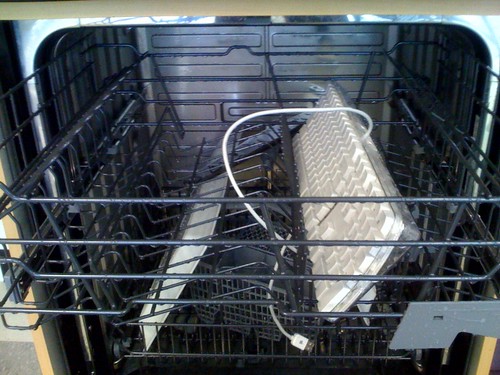
And for my next trick, a keyboard in the dishwasher!

"Correcting many months of breakfast bagel poppyseeds, crumbs and the occasional coffee drip; these things were sustainable events, but a beer spill was the thing that finally put it out of commission."

Setting aside the whole how do you get beer spilt into your office keyboard question* , Scott, if you’re going to clean your keyboard perhaps we should get one of these for the office instead …

Keyboard cleaning

… for a far more thorough solution?

Photos by .schill and Mrs eNil

* Answer, because that’s how we roll at flickrhq.

Who’s On First?

Untitled World View #1215585993

Normally we don’t talk about upcoming features but in recent weeks we’ve been hard-pressed to keep a lid on our renewed excitement for kittens. We’re betting 2009 will be a big year for kittens and it is why Dan and Heather are taking so much time to hash out the details for the new flickr.kittens API framework which we’re confident will re-embiggen-ize the how, the what and the why of photo-sharing!

To pass the time, until then, I’m going to talk about some of the geo-related API methods that have been released in the last few months, but perhaps not properly explained in detail and introduce a new minty-fresh method which hasn’t been discussed at all!

Cake for breakfast

First, the new stuff.

Places for a user

We’ve added a new authenticated method to the flickr.places namespace called flickr.places.placesForUser which returns the top 100 unique places, scoped by place type, where a user has geotagged photos. For example, I’ve geotagged photos in the following countries:

# ?method=flickr.places.placesForUser&place_type=country

<places total="7">
	<place place_id="4KO02SibApitvSBieQ" woeid="23424977"
		latitude="48.890" longitude="-116.982"
		place_url="/United+States" place_type="country"
		photo_count="1264">United States</place>
	<place place_id="EESRy8qbApgaeIkbsA" woeid="23424775"
		latitude="62.358" longitude="-96.582"
		place_url="/Canada" place_type="country"
		photo_count="307">Canada</place>

	<place place_id="3s63vaibApjQipWazQ" woeid="23424950"
		latitude="39.895" longitude="-2.988"
		place_url="/Spain" place_type="country"
		photo_count="67">Spain</place>
	<place place_id="6immEPubAphfvM5R0g" woeid="23424819"
		latitude="46.712" longitude="1.718"
		place_url="/France" place_type="country"
		photo_count="60">France</place>
	<place place_id="DevLebebApj4RVbtaQ" woeid="23424975"
		latitude="54.313" longitude="-2.232"
		place_url="/United+Kingdom" place_type="country"
		photo_count="34">United Kingdom</place>
	<place place_id="mSCQNWWbAphdLH6WDQ" woeid="23424812"
		latitude="64.950" longitude="26.064"
		place_url="/Finland" place_type="country"
		photo_count="24">Finland</place>

	<place place_id="mpa01jWbAphICsyCsA" woeid="23424853"
		latitude="42.502" longitude="12.573"
		place_url="/Italy" place_type="country"
		photo_count="8">Italy</place>
</places>

The response format is (almost) like all the other places methods, which I guess makes it a standard places response though we haven’t gotten around to standardizing it like we have with photos. Places responses will always contain a “place ID” and a “WOE ID”, a “latitude” and a “longitude”, a “place type” and a “place URL” attribute. They usually contain an “accuracy” attribute but it doesn’t make any sense in the a list of places for a user since the photos, clustered by place type, may have been geotagged at multiple zoom levels. In this example, we’ve also added a “photo count” attribute since that’s an interesting bit of information.

The list of place types with which to scope a query by is limited to a subset of the place types in the Flickr location hierarchy, specifically: neighbourhoods, localities (cities or towns), regions (states) and countries. While place_type is a required argument for the method, there are two other optional parameters you can use to filter your results.

Places for a user (and a place)

The first is woe_id and ensures that places of a given type also have a relationship with that WOE ID. For example, these are all the localities for my geotagged photos taken in Canada (WOE ID 23424775):

# ?method=flickr.places.placesForUser&place_type=locality&woe_id=23424775

<places total="5">
	<place place_id="4hLQygSaBJ92" woeid="3534"
		latitude="45.512" longitude="-73.554"
		place_url="/Canada/Quebec/Montreal" place_type="locality"
		photo_count="221">Montreal, Quebec</place>
	<place place_id="63v7zaqQCZxX" woeid="9807"
		latitude="49.260" longitude="-123.113"
		place_url="/Canada/British+Columbia/Vancouver" place_type="locality"
		photo_count="59">Vancouver, British Columbia</place>
	<place place_id="zrCws.mQCZj_" woeid="9848"
		latitude="48.428" longitude="-123.364"
		place_url="/Canada/British+Columbia/Victoria" place_type="locality"
		photo_count="9">Victoria, British Columbia</place>

	<place place_id="WzwcDQCdAJsL" woeid="4177"
		latitude="44.646" longitude="-63.573"
		place_url="/Canada/Nova+Scotia/Halifax" place_type="locality"
		photo_count="3">Halifax, Nova Scotia</place>
	<place place_id="XlQb2xedAJvr" woeid="4176"
		latitude="44.673" longitude="-63.575"
		place_url="/Canada/Nova+Scotia/Dartmouth" place_type="locality"
		photo_count="1">Dartmouth, Nova Scotia</place>
</places>

(Most) places for a user (and a place)

The second optional parameter is threshold which requires a place have a minimum number of photos associated with it in order to be included in the result set. Any place that falls below the threshold will be rolled-up in to its parent location. For example, if we search for localities in Canada but also a minimum threshold of 5 photos per location the towns of Halifax and Dartmouth are rolled up in to the province of Nova Scotia:

# ?method=flickr.places.placesForUser&place_type=locality&woe_id=23424775&threshold=5

<places total="4">
	<place place_id="4hLQygSaBJ92" woeid="3534"
		latitude="45.512" longitude="-73.554"
		place_url="/Canada/Quebec/Montreal" place_type="locality"
		photo_count="221">Montreal, Quebec</place>

	<place place_id="63v7zaqQCZxX" woeid="9807"
		latitude="49.260" longitude="-123.113"
		place_url="/Canada/British+Columbia/Vancouver" place_type="locality"
		photo_count="59">Vancouver, British Columbia</place>
	<place place_id="zrCws.mQCZj_" woeid="9848"
		latitude="48.428" longitude="-123.364"
		place_url="/Canada/British+Columbia/Victoria" place_type="locality"
		photo_count="9">Victoria, British Columbia</place>
	<place place_id="QpsBIhybAphCEFAm" woeid="2344921"
		latitude="44.727" longitude="-63.587"
		place_url="/Canada/Nova+Scotia" place_type="region"
		photo_count="4">Nova Scotia, CA</place>
</places>

Note that we only roll up a single level so if, like the Halifax and Dartmouth, a locality gets rolled up in to its parent region it may still have fewer photos associated with it than the threshold you passed with the method call. If you think this is crazy talk and/or have some other use case we haven’t considered with this model tell us why and we can revisit the decision.

Untitled Relationship #1219894402

Finally, as mentioned above the flickr.places.placesForUser method requires that you include an auth token with minimum read permissions. As always, please take extra care to respect people’s senstitivies when it comes to location data and, above all, don’t be creepy.

Meanwhile, back at the Ranch

About a week ago, I was asked whether it was possible to use the Flickr API to get a feed of geotagged photos (for a particular place/radius) sorted by interestingness, filtered by CC license to which I quickly replied: WOE IDs, the flickr.places APIs and the “radius” parameter in the flickr.photos.search method should get you what you need! (Also the API responses as syndication feeds support, if you’re being finnicky about the question.)

Which got me thinking that while we’ve told people about WOE IDs and the Places API we haven’t really made a lot of noise about the addition of radial queries and the has_geo flag to the flickr.photos.search method. We’ve mentioned it in passing, here and there, but never really tied it all together. So, let’s start with WOE IDs:

WOE (short for Where On Earth) IDs are the unique identifiers in the giant database of places that we (and FireEagle and the rest of Yahoo!) use to keep track of where stuff is. They are also available to you and the rest of the Internets via the public GeoPlanet API. In Flickr, every geotagged photo has up to (6) associated WOE IDs representing a neighbourhood, locality, county (if present), region, country and continent.

Geocoding

Using the example above, you could start with an API call to the flickr.places.find method which is like an extra-magic geocoder: It not only resolves places names to latitude and longitude coordinates but also returns the WOE ID for the place that contains it. Searching for “San Francisco CA” returns WOE ID 2487956 which you can use to call the flickr.photos.search method asking for all the photos geotagged in the city of San Francisco sorted by interestingness with a Creative Commons Attribution license. Something like this:

# ?method=flickr.places.find&query=San+Francisco+CA

<places query="San Francisco CA" total="1">
	<place place_id="kH8dLOubBZRvX_YZ" woeid="2487956" latitude="37.779"
       	longitude="-122.420" place_url="/United+States/California/San+Francisco"
       	place_type="locality">San Francisco, California, United States</place>
</places>

# ?method=flickr.photos.search&license=4&sort=interestingness-desc 
# 	&woe_id=2487956&extras=tags,geo,license


<photos page="1" pages="289" perpage="100" total="28809">
	<photo id="145874931" owner="37996593020@N01" secret="b695138626" server="52"
       	farm="1" title="bridge" ispublic="1" isfriend="0" isfamily="0"
       	tags="sanfrancisco bridge water night reflections geotagged lights
       	baybridge geolat3779274 geolon12239096 sfchronicle96hours
       	sanfranciscochronicle96hours" latitude="37.79274" longitude="-122.39096"
       	accuracy="16" license="4"
		place_id="kH8dLOubBZRvX_YZ" woeid="2487956"/>

	<!-- and so on -->
</photos>

Reverse geocoding

You can also lookup the WOE ID for any set of latitude and longitude coordinates. Imagine that you are standing in front the infamous Wall of Rant in San Francisco’s Mission district and you’d like to see photos for the rest of the neighbourhood.

Picture 1

If you know your geo coordinates you can call the flickr.places.findByLatLon method to reverse geocode a point to its nearest WOE ID which can then be used to call the trusty flickr.photos.search method. Like this (without the photos.search part since it’s basically the same as above):

# ?method=flickr.places.findByLatLon&lat=37.752969&lon=-122.420844

<places latitude="37.752969" longitude="-122.420844" accuracy="16" total="1">
	<place place_id="C.JdRBObBZkMAKSJ" woeid="2452334"
	    latitude="37.759" longitude="-122.418"
	    place_url="/United+States/California/San+Francisco/Mission"
	    place_type="neighbourhood"/>
</places>

Nearby

But what if you just want to see photos nearby a point? Radial queries, recently added to the photos.search method, allow you to pass lat and lon parameters and ask Flickr to “show me all the photos within an (n) km radius of a point”. You have always been able to do something like this using the bbox parameter but radial queries differ in two ways:

  1. They also save you from having to calculate a bounding box which is, you know, boring.
  2. Results are sorted by distance from the center point (you can override this by setting the sort parameter). Trying to do the same with a bounding box query would mean fetching all the results first and then sorting them which both expensive and boring and breaks the pagination model.

Radial queries are not meant for pulling all the photos at the country or even state level and as such the maximum allowable radius is 32 kilometers (or 20 miles). The default value is 5 and you can toggle between metric and imperial by assigning the radius_units parameter a value of “km” or “mi” (the default is “km”).

# ?method=flickr.photos.search&lat=37.752969&lon=-122.420844 
# 	&radius=1&extras=geo,tags&min_taken_date=2008-09-01+00%3A00%3A00


<photos page="1" pages="1" perpage="100" total="9">
	<photo id="2820548158" owner="29072902@N00" secret="b2fc694880" server="3288"
		farm="4" title="20080901130811" ispublic="1" isfriend="0" isfamily="0"
		latitude="37.751166" longitude="-122.418833" accuracy="16"
		place_id="C.JdRBObBZkMAKSJ" woeid="2452334"
		tags="moblog shinobu"/>

	<!-- and so on -->
</photos>

See that min_taken_date parameter? Like all geo-related query hooks in the flickr.photos.search method you need to pass some sort of limiting agent: a tag, a user ID, a date range, etc. If you insist on passing a pure geo query we will automagically assign a limiting agent of photos taken within the last 12 hours.

(I can) has geo

Finally (no, really) if you just want to keep things simple and use a tag search you can also call the flickr.photos.search method with the has_geo argument which will scope your query to only those photos which have been geotagged. For example, searching for all geotagged photos of kittens taken in tokyo:

# ?method=flickr.photos.search&tags=tokyo,kitten&tag_mode=all 
# 	&has_geo=1&extras=tags,geo

<photos page="1" pages="1" perpage="100" total="60">
	<photo id="2619847035" owner="27921677@N00" secret="0979aed596" server="3011"
       		farm="4" title="Kittens in Akiba" ispublic="1" isfriend="0" isfamily="0"
       		tags="japan cat tokyo kitten crowd akihabara unexpected"
		latitude="35.698263" longitude="139.771977" accuracy="16"
		place_id="aod14iaYAJ1rDE.R" woeid="1118370"/>

	<!-- and so on -->

</photos>

Maps are purrrr-ty

Which is a nice segueway in to telling you that on Tuesday we turned on the map-love for
the city of Tokyo, in addition to Beijing and Black Rock City (aka Burning Man), using the Creative Commons licensed tiles produced by the good people at Open Street Maps. We’re pretty excited about this but rather than just showing another before and after screenshot we decided that the best way to showcase the new tiles was with… well, kittens of course!

Picture 1

Sophie’s Choice by tenaciousme

Enjoy!

That’s a lot to digest in one go but we promise there won’t be a pop quiz on Monday. Hopefully there’s something useful for you in the twisty maze of possibilities, now or in an oh yeah, what about… moment in the future, and maybe even the seed for a brand new API application. Kittens!

Kitten Tuesday

Last Tuesday our "sister" site blog.flickr had "other ideas " about what Kitten Tuesday means. With a positive plethora of photos and videos they go totally to town with kittens, and why the heck not?

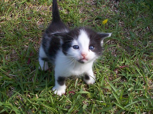
If you’re into an excess of artistic bourgeoisie I guess, meanwhile, over here on the Dev blog, we’re all about simplicity, efficiency and optimization. Where Kitten Tuesday is just that, a Kitten on Tuesday, otherwise we may as well have Furry Friday Fiesta.

So without further ado, A reader writes:

"We’re loving Kitten Tuesdays. Any chance you could consider JJ for a future appearance?"

Why of course, here’s JJ …

Photo by Chubby Bat

Machine Tags, last.fm and Rock’n’Roll

You Rock, go to gigs and take photos, yes?

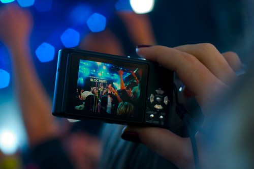
Bloc Party Photo (in a Photo)

Love last.fm too?

Yeah well, so do we. Turns out they love us as well. For over a year now they’ve been encouraging their users to machine tag flickr photos with last.fm event ids. This is what Martin had to say …

“As a geek I’m quite intrigued by Flickr’s machine tags feature we’re using to create this Last.fm/Flickr integration — it can become the basis for a number of interesting Flickr tools, and I’m confident people will come up with all kind of great ideas. (I’m personally waiting for someone to develop a Flickr tool to automatically geotag your event photos based on the venue address provided by Last.fm).”

(It takes us a while, but we’ll probably get round to that geotagging thing ‘soon’ Martin)

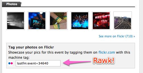
Here’s how they do it; from a specific event page on last.fm you’ll see this …

last fm help

… telling you which machine tag to use.

You took some photos at the gig? Well then, throw the tag in there and computers will automatically do the rest. From last.fm’s end, they grab the photos from flickr to show on each event page … it’s also a great way to find other people who were at the same gig as you!

From our end (as of a few weeks ago thanks to Cal) it’ll look like this …

last.fm machine tag

… a rather fetching last.fm icon, giving you the badge of honor telling everyone that you were really there and therefore how you loved LCD Soundsystem before everyone else.

If its an event we know about then we’ll already have the name. If its a brand spanking new event, we’ll get our system to talk to last.fm’s system, last.fm’s system will invite our system in for coffee, our system will play hard to get for a while, and then in the morning over fried eggs and bacon our system will have the new event name (honestly this is how it works, you should Cal’s code!).

So how many photos are tagged with last.fm events? Well around 621,793 last time I checked.

See more photos from Heineken Open’er Festival 2007 (last.fm).

Photo by alex-pl

Flickr [heart] Burning Man [heart] OpenStreetMap

[new map tiles]

Everybody loves Burning Man!

Well I don’t, but then I’m grumpy like that. Anyway, imagine my excitement waking up this morning knowing that Burning Man 2008 had just started. Here’s where the photos will start appearing as people get re-hydrated and find an internet connection …

Your maps not on OSM

Imagine my excitement even more when I saw on Mikel’s blog that OpenStreetMap (OSM) had pushed new map data (and tiles) out the door for this years burning man, see Burning Man Earth Information Release for no more information what-so-ever ;) Hopefully Mikel will update soon with all the work that went into it.

A quick tile shuffle later, like what we did for Beijing, and we once more have OSM live in Flickr …

Your maps on OSM

So when all those burners come back, it should be easily for them (you know, relatively) to drop those photos onto the map. Why not go see the new map for yourself, it’s rather pretty.

George summed it up well when she said

“That’s part of what appealed to us so much about a fantastic project called OpenStreetMap – a free, editable map of the world, made by the people in it. What an exciting prospect to be able to see maps that are alive and have been lovingly created by citizen cartographers all over the world.”

It’s the power of The Creative Commons (and even more importantly, people) that make stuff like this work, and obviously we’re hoping to continue to do more. The glib answer I give for why this this sort of thing is important is so I can say “If you’re upset that we don’t have map coverage for where you are, you can grab some friends, go out, and make some”.

As sort-of true as that is, probably a better answer is to read Mikel’s posts on Mapping the West Bank and Ups and Downs Mapping the West Bank (once his server recovers from whatever is hitting it, not us!). Which will hopefully illustrate far better than Burning Man why user created mapping data that can be used by anyone willing to use the CC Attribution-Share Alike license, is important.

API Responses as Feeds

You know three things that would be cool?

  • the ability to subscribe to the output of a Flickr API call in a feed aggregator
  • the ability to get the results of Flickr API calls as KML (or GeoRSS)
  • if all those devices that support RSS feeds (like photo frames!) also supported the Flickr API.

You see where I’m going with this don’t you?

You can already specify that you want the output format of a Flickr API call to be REST (POX), XML-RPC, SOAP (shudder, not sure that one still works), JSON, or serialized PHP. We always wanted to support formats like KML, or Atom but we were never quite sure how to represent the results of a call to flickr.photos.getInfo() or flickr.photos.licenses.getInfo() as a KML.

Last week we finally got around to pushing out our 80% solution — an experimental response format for API methods that use the standard photos response format that allows you to request API responses as as one of our many feed formats.

You can now get the output of flickr.photos.search(), or flickr.favorites.getList() as Atom, or GeoRSS, or KML, or whatever.

API Feed Types

The syntax is "&format=feed-{SOME_FEED_IDENTIFER}" where the feed identifiers follow the same convention you use when fetching…feeds.

  • feed-rss_100, API results will be returned as a RSS 1.0 feed
  • feed-rss_200, API results will be returned as a RSS 2.0 feed
  • feed-atom_10, API results will be returned as a Atom 1.0 feed
  • feed-georss, API results will be returned as a RSS 2.0 feed
    with corresponding GeoRSS and W3C Geo elements for geotagged
    photos
  • feed-geoatom, API results will be returned as a Atom 1.0 feed
    with corresponding GeoRSS and W3C Geo elements for geotagged
    photos
  • feed-geordf, API results will be returned as a RSS 1.0 feed
    with corresponding GeoRSS and W3C Geo elements for geotagged
    photos
  • feed-kml, API results will be returned as a KML 2.1 feed
  • feed-kml_nl, API results will be returned as a KML 2.1 network
    link feed

And remember, format is an API arg, and needs to be included in your API signature if you’re making a signed API call.

Namespaces, pagination, bits and bobs

You’ll find the feeds now include the venerable xmlns:flickr=”urn:flickr:” namespace. This is used to declare bits that don’t fit elsewhere like pagination.

Pagination information is passed as a single namespaced (‘urn:flickr:)
element under the feed’s root (or “channel” element if it has one). For
everything but RSS 1.0 based feeds it looks like this:

<flickr:pagination total="480" page="1" pages="96"
per_page="5" />

For RSS 1.0 we do a little RDF dance:

<flickr:flickr>
     <pagination>
             <total>480</total>
             <page>1</page>
                 <pages>32</pages>
             <per_page>15</per_page>
     </pagination>
</flickr:flickr>

Speaking of pagination, to start with we’ve enforced a maximum “per
page” limit of 15. If people have a reasonable use case we may
consider raising the limit but otherwise we need to account for the
extra data/size that feed formats add.

You’ll also find some extras like

<entry>
    ...
    <flickr:views>3</flickr:views>
    <flickr:original type="png" href="http://farm4.static.flickr.com/3074/2783931781_12f84e4079_o.png" width="640" height="480" />
</entry>

Error Handling

If an error occurs, the API will return a 400 HTTP status code.

Flickr error codes and message are returned as X-FlickrErrCode and X-FlickrErrMessage
HTTP headers. For example:

X-FlickrErrCode: 111
X-FlickrErrMessage: Format "feed-lolcat" not found

Caveats and Warnings

  • This is EXPERIMENTAL. It might change, it might go away, but we hope not. We also could potentially make it better based on all your awesome feedback.

  • This is not available for all methods. If you call photos.getInfo and
    ask for a feed response format all you will get is an error.

  • Just like any API call (or feed usage or really anything else) you are required to respect the copyright of the photographer.

  • These are still API calls. All the usual rules about usage apply.
    You are still bound by the Flickr API TOU and any other rules,
    capricious or not, we apply to API usage. Including rate limits. If
    you feed this in to an overly-aggressive aggregator we will make your
    API key cry. (In an entirely non-creepy way)

Putting it together: ego feeds

Turns out ‘kellan’ is a popular baby name these days, so whenever I go ego surfing Flickr I tend to see pictures of two year olds. This changes (for now) when I limit my searching to my friends photos. Using API feeds I can now build an ego feed of photos from my friends, like so:

flickr.photos.search:
   user_id => 51035734193@N01,
   contacts => all,
   text => kellan,
   sort => date-posted-desc,
   api_key => {API_KEY}
   auth_token => {AUTH_TOKEN}
   format => feed-atom_10

api.flickr.com/services/rest/?auth_token=xxxx&user_id=51035734193%40N01&
   contacts=all&format=feed-atom_10&sort=date-posted-desc&text=kellan
   &api_key=xxxx&method=flickr.photos.search&api_sig=xxxx

Putting it together: near home

Or a KML feed of the most interesting, safe, CC licensed photos, within 10 kilometers of a point (say your home), suitable for remixing:

flickr.photos.search:
   license => 1,2,4,5,7,
   sort => interestingness-desc,
   lat => 40.661699,
   lon => -73.98947,
   radius => 10,
   safe_search => 1,
   api_key => {API_KEY}
   format => feed-kml

api.flickr.com/services/rest/?auth_token=xxx&license=1%2C2%2C4%2C5%2C7&
  lat=40.661699&lon=-73.98947&radius=10&safe_search=1
  &format=feed-atom_10&api_key=xxxx&method=flickr.photos.search
  &api_sig=xxxxx

You get the idea.

Standard Photos Response, APIs for a civilized age.

Funny story. I went to write a blog post and when the time came to link to the documentation of our standard “standard photos response” structure, I found we had never documented it!

Okay. Maybe that wasn’t so funny.

But anyway, this is the blog post before that other blog post, so that when I write that other blog post I’ve got something to point to.

And besides you should know this stuff if you’re using the API. It’s good stuff.

Standard Photos Response

The standard photos response is a data structure that we use when we want to return a list of photos. Most prominently the ever popular swiss-army-API flickr.photos.search() uses it, but also methods like flickr.favorites.getList() or flickr.groups.pools.getPhotos().

Beyond a common structure that gets serialized across all our different API response formats, standard photos response methods share a common set of arguments for sorting and paging (after all these are lists of photos), and the special extras argument.

Standard Photo Response, the XML Serialization

You’re basic standard photos response looks like this. It’s just an envelope for delivering a list of photos.

<rsp stat="ok">
  <photos page="1" pages="7" perpage="100" total="608">
    <photo id="2777191844" owner="51035734193@N01" secret="653a19d017" server="3059" farm="4" title="FAIL" ispublic="1" isfriend="0" isfamily="0"/>
    <photo id="2771521705" owner="51035734193@N01" secret="1878507379" server="3178" farm="4" title="In the street" ispublic="1" isfriend="0" isfamily="0"/>
  </photos>
</rsp>

We’ve got the standard Flickr <rsp> root element, a <photos> container describing the full list and the page we’re on, and some <photo> elements that include everything we need to display a photo.

extras: the concept

Another largely undocumented deep structure in the Flickr API is a distinction between getList() and getInfo() methods. We tend to return a pared down list of identifiers, and provide methods for getting more info about individual items. Generally it’s a very useful pattern, and saves us all bandwidth, processing, and data rot.

However sometimes (often?) you’re wanting to display a bunch of photos, and having to roundtrip to call flickr.photos.getInfo() for every single one of them is annoying. (not to mention slow, and likely to get you frowned upon by our ops team)

That’s where extras come in. The idea behind extras is you can selectively enrich the bare bones list I showed you earlier with the metadata you need to display your bunch of photos, without the round trip, and without fetching more then you’ll need.

extras: the details

There are currently 13 different extras available, and we add new ones periodically as new concepts come online, or you make a compelling enough case for them.

As of today they are: license, date_upload, date_taken, owner_name, icon_server, original_format, last_update, geo, tags, machine_tags, o_dims, views, media.

license

Is the photo “All rights reversed”? Licensed under one of the CC license?

<photo id="2777191844" owner="51035734193@N01" secret="653a19d017"
 server="3059" farm="4" title="FAIL" ispublic="1" isfriend="0" isfamily="0" 
 license="3"/>

license=”3” means Attribution-NonCommercial-NoDerivs, you can get our mappings with flickr.photos.licenses.getInfo().

date_upload, date_taken, last_update

When was the photo uploaded to Flickr? When do we think it was taken? When was its metadata last twiddled?

<photo id="2772368826" owner="51035734193@N01" secret="1078392104"
 server="3122" farm="4"       title="Finger on the button" ispublic="1" isfriend="0" isfamily="0"
 license="3"  dateupload="1219006901" datetaken="2008-08-17 12:38:06" 
datetakengranularity="0"     lastupdate="1219117103"/>

Yes the extras param is called date_upload the attribute is dateupload, what can I say, legacy. Notice also that dateupload and lastupdate are epoch seconds, while datetakengranularity is probably best ignored.

owner_name and icon_server

Everything you need to properly credit the photographer, including their name, and the info necessary to display their buddyicon.

<photo id="2772368826" owner="51035734193@N01" secret="1078392104" 
server="3122" farm="4" title="Finger on the button" ispublic="1" isfriend="0" isfamily="0" 
ownername="kellan" iconserver="54" iconfarm="1"/>

geo

If the photo was geotagged include the latitude, longitude, and accuracy of the geotagging.

<photo id="2772368826" owner="51035734193@N01" secret="1078392104" 
server="3122" farm="4" title="Finger on the button" ispublic="1" isfriend="0" isfamily="0" 
latitude="40.714666" longitude="73.957333" accuracy="16"/>

tags and machine_tags

Note these are the “clean” versions of the tags and machine tags, which means spaces, and most punctuation will have been stripped. Safe to display in HTML, and useable as URL fragments.

<photo id="2772368826" owner="51035734193@N01" secret="1078392104" 
server="3122" farm="4" title="Finger on the button" ispublic="1" isfriend="0" isfamily="0" 
tags="nyc streetart williamsburg ph:camera=iphone3g" 
machine_tags="ph:camera=iphone3g"/>

original_format and o_dims

Assuming you’re making API calls as a member who is authorized to download a photo (e.g. the photographer) you can ask for details about the unmodified, full resolution photo that was uploaded. Get the original file format, the secret needed to construct the URL to the photo, and what the original’s dimensions are.

<photo id="2772368826" owner="51035734193@N01" secret="1078392104" 
server="3122" farm="4" title="Finger on the button" ispublic="1" isfriend="0" isfamily="0" 
originalsecret="xxxxxxxx" originalformat="jpg" o_width="1200" 
o_height="1600"/>

views

How many times has this photo been viewed by folks other then the person who uploaded it?

<photo id="2772368826" owner="51035734193@N01" secret="1078392104" 
server="3122" farm="4" title="Finger on the button" ispublic="1" isfriend="0" isfamily="0" 
views="9"/>

media

Is it a photo? Or a video? Has it been processed and is it ready for displaying? (media_status is a lot more useful for videos)

<photo id="2771521705" owner="51035734193@N01" secret="1878507379" 
server="3178" farm="4" title="In the street" ispublic="1" isfriend="0" isfamily="0" 
media="photo" media_status="ready"/>

Wow. What a list. Really, what more could anyone ever want? (that’s rhetorical)

The punch line

That’s standard photos responses, and how to use extras (paging and sorting is left as an exercise to the reader). Mastering the format is the key to building both interesting and performant API applications. use the metadata, love the metadata, and ditch the round trip.

And now for the that next blog post I mentioned ….

Defining the boundaries we are all within

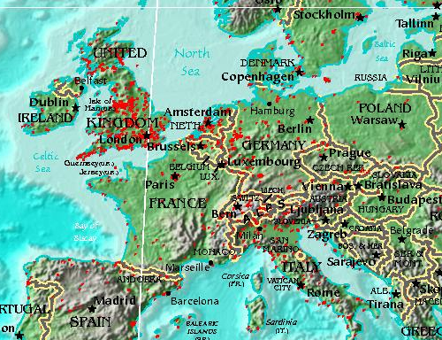
Last week I made a blog post about what we call ‘corrections’ and because a picture is worth a thousand words, here’s where people have been fixing things in Europe …

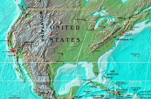
… and over in the US …


… as expected most of the corrections to neighborhoods are taking place in major cities. Also seemingly most of the UK, presumably because the population is high and our current data is messy (or too abstract) there.

As we get more of this stuff back, the process of feeding it into the system will get underway (in some form or other).

I wonder that as that happens, we’ll see the corrections move away from already heavily corrected locations like cities, or if they’ll continue to be areas that appear to have highly contested borders.

Only time will tell I guess, we’ll keep tracking it.

Map extracts taken from this world map by Serguei.