The great map update of 2012

Today we are announcing an update to the map tiles which we use site wide. A very high majority of the globe will be represented by Nokia’s clever looking tiles.

Nokia map tile

We are not stopping there. As some of you may know, Flickr has been using Open Street Maps (OSM) data to make map tiles for some places. We started with Beijing and the list has grown to twenty one additional places:

Mogadishu
Cairo
Algiers
Kiev
Tokyo
Tehran
Hanoi
Ho Chi Minh City
Manila
Davao
Cebu
Baghdad
Kabul
Accra
Hispaniola
Havana
Kinshasa
Harare
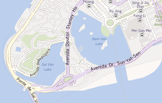
Nairobi
Buenos aires
Santiago

It has been a while since we last updated our OSM tiles. Since 2009, the OSM community has advanced quite a bit in the tools they provide and data quality. I went into a little detail about this in a talk I gave last year.

Introducing Pandonia

Nokia map tile

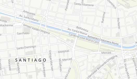
Today we are launching Buenos Aires and Santiago in a new style. We will be launching more cities in this new style in the near future. They are built from more recent OSM data and they will also have an entirely new style which we call Pandonia. Our new style was designed in TileMill from the osm-bright template, both created by the rad team at MapBox. TileMill changes the game when it comes to styling map tiles. The interface is developed to let you quickly iterate style changes to tiles and see the changes immediately. Ross Harmes will be writing a more detailed account of the work he did to create the Pandonia style. We appreciate the tips and guidance from Eric Gunderson, Tom MacWright, and the rest of the team at MapBox

We are looking forward to updating all of our OSM places with the Pandonia style in the near future and growing to more places after that… Antarctica? Null Island? The Moon? Stay tuned and see…

Changing our Javascript API

To host all of these new tiles we needed to find a flexible javascript api. Cloudmade’s Leaflet is a simple and open source tile serving javascript library. The events and methods map well to our previous JS API, which made upgrading simple for us. All of our existing map interfaces will stay the same with the addition of modern map tiles. They will also support touch screen devices better than ever. Leaflet’s layers mechanism will make it easier for us to blend different tile sources together seamlessly. We have a fork on GitHub which we plan to contribute to as time goes on. We’ll keep you posted.

horse=yes

a map Jason Bourne could eat cake on

Yes, I got a bit emotional at the third OpenStreetMap conference, held in the CCC, Amsterdam last weekend — mainly because this globe we are on is the only one we know — we really are mapping our universe, doing it our way. Creating the world we want to live in. I thought it worth while to say “Thanks” to some people. Being British, the feeling of being a bit foolish stopped me from being too effusive!

Tim Waters

A couple weeks ago I had the pleasure of attending, and the privilege of speaking at, the State of the Map conference in Amsterdam. I told the story of how we came to use Open Street Maps (OSM), how it works on the backend and talked a little bit about what we’d like to do next: Moving beyond “bags of tiles”, a better way to keep up to date with changes to the OSM database and, for good measure, a little bit of tree-hugging at the end.

Most of all, though, I wanted to take the opportunity to thank the OSM community. To thank them for making Flickr, the thing that we care about and work on all day, better. To thank them for proving the nay-sayers wrong.

To say that OSM started with an audacious plan (to map the entire world by “hand” one neighbourhood and one person at a time) would be an understatement. You would have been forgiven, at the time, for laughing.

And yet, in a few short years they are well on their way having nurtured both a community of users and an infrastructure of tools that makes it hard to ever imagine a world without Open Street Maps. In the U.K. alone, as Muki Haklay demonstrated, they have produced a free and open dataset whose coverage and fidelity rivals those created by the Ordinance Survey with its government funding and 250-year head start.

That is really exciting both because of the opportunities that such a rich and comprehensive dataset provide but also because it proves what is possible. The Internets are still a pretty great place that way.

mugs

photo by russelldavies

There were too many excellent talks to list them all, but here’s a short (ish) list that betrays some of my interests and biases:

  • Harry Wood’s talk on tagging in OSM. I actually missed this talk and after seeing the slides I am doubly disappointed. Open Street Map is not just the raw geographic data that people collect but also all the metadata that is used to describe it. OSM uses a simple tagging system for recording “map features” and Harry’s talk on managing the chaos, navigating the disputes and juggling the possibilities looked like it was really interesting.

    (The title of this post is, in fact, a gentle poke at the black sheep of the OSM tagging world. There really are map features tagged “horse=yes” which is mostly hilarious until you remember how much has been accomplished with a framework that allows for tags like that.)

  • The Sunday afternoon maps-and-history love-fest that included Frankie Roberto’s “Mapping History on Open Street Map“, Tim Water’s “Open Historical Maps” and the Dutch Nationaal Archief’s presenting “MapIt 1418“, a project to allow users to add suggested locations for their photos in the Flickr Commons!

    Tim’s been doing work for The New York Public Library, another Flickr Commons member, and MapWarper (the code that powers the NYPL’s historical map rectifier) is an open source project and available on GitHub.

  • Mikel Maron’s “Free and Open Palestine” (the slides are here but you should really watch the video) which is an amazing story of collecting map data in the West Bank and Gaza.

    Mikel was also instrumental in creating a scholarship program to pay the travel and lodging expenses for 15 members from the OSM community, from all over the world, to attend the conference. Because he’s kind of awesome, that way.

But that’s just me. I’d encourage you to spend some time poking around all the other presentations that are available online:

Despite the “bag of tiles” approach for using OSM on Flickr getting a bit old it still works so as of right here, right now:

We’ve also refreshed the tiles for Beijing and Tehran where, I’m told, the OSM community has added twice as much data since we first started showing (OSM) maps a month ago!

If it sometimes seems like we’re doing all of this in a bit of an ad hoc fashion that’s because we (mostly) are. How and when and where are all details we need to work out going forward but, in the meantime, we have map tiles where there were none before so it can’t be all bad.

Finally, because the actual decision to attend the conference was so last minute I did not get the memo to all presenters to include a funny picture of SteveC (one of the original founders of Open Street Maps) in their slides.

To make up for that omission, I leave you now with the one-and-only Steve Coast.

Steve *loves* Yahoo

photo by Andy Hume